Agua Caliente Indian Reservation
Agua Caliente Indian Reservation is located in Southern California.
The Agua Caliente Indian Reservation occupies 126.706 km2 (48.921 sq mi),
including parts of the cities of Palm Springs, Cathedral City, and Rancho
Mirage.
Location
Palm Springs, Riverside County
California,
USA
Getting There
There are several ways to get there depending on your starting location.
Here are some options:
By car: If you have access to a car, you can drive to the reservation. Agua
Caliente Indian Reservation is located in the Coachella Valley, which is about
two hours east of Los Angeles and about 30 minutes south of Palm Springs. From
Los Angeles, take Interstate 10 East and exit on Bob Hope Drive or Ramon Road.
From Palm Springs, take Highway 111 south to either Bob Hope Drive or Ramon
Road.
By air: The nearest airport is
Palm Springs International Airport, which is
located about 10 miles north of the reservation. From the airport, you can rent
a car or take a taxi or shuttle to the reservation.
By bus: There are several bus companies that offer service to Palm Springs,
including Greyhound and Amtrak. From Palm Springs, you can take a taxi or
shuttle to the reservation.
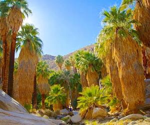
Once you arrive at Agua Caliente Indian Reservation, there are several
attractions to explore, including the Indian Canyons, Palm Springs Art Museum,
and the Spa Resort Casino.
Nearby Airports
This is a list of primary airports in California that have scheduled passenger service on commercial airlines.
undo Major Attractions in California