Las Vegas Strip
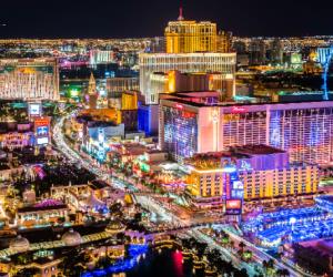
The Las Vegas Strip is a stretch of Las Vegas Boulevard South known for its
concentration of resort hotels and casinos. Fifteen of the world's 25 largest
hotels by room count are on the Strip, with a total of over 62,000 rooms.
The Strip is approximately 4.2 miles (6.8 km) in length, located immediately
south of the Las Vegas city limits in the unincorporated towns of Paradise and
Winchester. However, the Strip is often referred to as being "in Las Vegas".
Location
Las Vegas Boulevard between Sahara Avenue and Russell Road
Clark County, Nevada
USA
Getting There
It is home to many of the world's largest hotels and casinos, as well as
numerous restaurants, shops, and entertainment venues. Public transportation
options to the Las Vegas Strip include the Las Vegas Monorail, which runs along
the east side of the Strip from the MGM Grand to the Sahara Las Vegas, and the
Regional Transportation Commission (RTC) buses, which run up and down the Strip
and connect to other parts of the city. Additionally, many hotels and casinos on
the Strip offer free shuttle services to nearby attractions and other parts of
the city.
Nearby Airports
This is a list of primary airports in Nevada that have scheduled passenger service on commercial airlines.
| Airports in Nevada |
|---|
|
•
Boulder City Municipal Airport |
undo Major Attractions in Nevada