Mount Mansfield
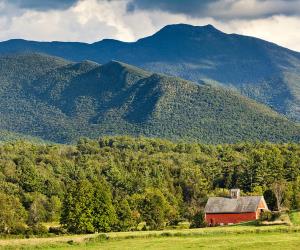
Mount Mansfield is the highest mountain in Vermont with a summit that peaks at
4,393 feet (1,339 m) above sea level. When viewed from the east or west, this
mountain has the appearance of a human profile, with distinct forehead, nose,
lips, chin, and Adam.
The summit located within the town of Underhill in Chittenden County; the
ridgeline, including some secondary peaks, extends into the town of Stowe, and
the mountain's flanks also reach into the town of Cambridge.
The mountain is used for various recreational and commercial purposes. "The
Nose" is home to transmitter towers for a number of regional radio and TV
stations. There are many hiking trails, including the Long Trail, which
traverses the main ridgeline.
In addition, the east flank of the mountain is used by the Stowe Mountain Resort
for winter skiing. A popular tourist activity is to take the toll road (about 4
miles (6.4 km), steep, mostly unpaved, with several hairpin turns) from the
Stowe Base Lodge to "The Nose" and hike along the ridge to "The Chin."
Location
Underhill, Chittenden County
Vermont
USA
Getting There
Mount Mansfield is the highest peak in Vermont and is located in the northern
part of the state. To get there by public transportation, you can take the
Amtrak train to Essex Junction or Waterbury Station, both of which are about 30
minutes away from the mountain by car. From there, you can take a taxi or
ride-sharing service to the mountain. There is also a bus service called the
Green Mountain Transit that operates in the area, but it may not be the most
convenient option for getting to Mount Mansfield. It's recommended to check the
schedules and routes of both the train and bus service beforehand to plan your
trip accordingly.
Nearby Airports
This is a list of primary airports in Vermont that have scheduled passenger service on commercial airlines.
| Airports in Vermont |
|---|
undo Major Attractions in Vermont